

Differential erosion
The process by which rocks of different hardness erode at different speeds, producing stepped relief and contrasting landforms.
Volcanic construction and erosional dismantling: ravines, cliffs, valleys and collapses that sculpt the present landscape.
The Canary Islands are volcanic edifices that grow upward from the seabed, but they also begin to be dismantled from the moment they emerge. Erosion acts on rocks of different resistance, carving ravines, cliffs, valleys and coastal platforms. This process is not uniform: a hard basalt flow may resist for millions of years while a soft ash deposit disappears in tens of thousands. The difference between construction and destruction shapes each island as much as volcanic activity itself. In some cases, instability of an edifice flank produces gigantic landslides that remove whole sectors of the volcano and deposit millions of cubic metres of material on the seabed. These collapses are not minor events: they reconfigure the landscape, generated tsunamis in the past and leave amphitheatres open to the sea that may later be partly filled by new lava flows. Recognising the traces of erosion and landslides is essential to understanding that the present landscape is not only the result of what was built, but also of what has been lost.[1][2]
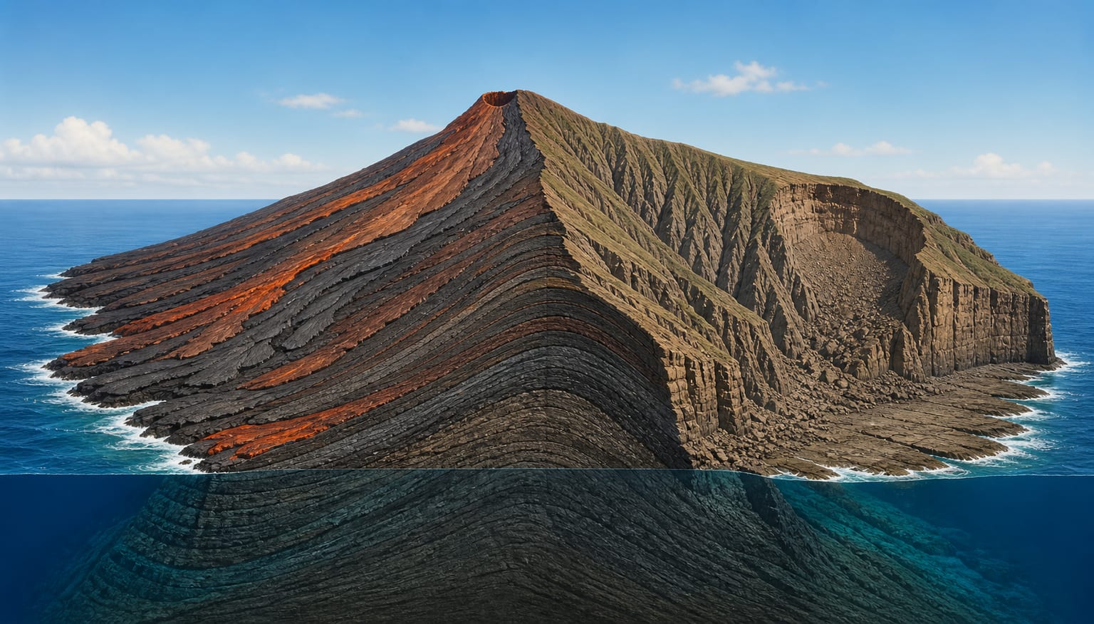
The relief of the Canaries is the result of a competition between two opposing processes: the accumulation of volcanic materials that build the edifice upward, and erosion that dismantles it downward. During the shield stage, construction dominates and the edifice grows rapidly. When activity decreases or stops, erosion takes control and begins to carve ravines and valleys.[1]
The resistance of each rock to wear marks the speed of erosion. Compact basalts form escarpments and boxed-in ravines; ash and lapilli deposits erode into gentle slopes. This selectivity produces the stepped relief seen on many Canarian hillsides, where hard and soft layers alternate.[1]
Ravines are the most characteristic erosive landforms of the Canarian landscape. They form from the concentration of rainwater on sparsely vegetated surfaces and from the low infiltration on compact basalt-flow areas. Unlike permanent rivers, ravines only carry water during and after rainfall, but their erosive capacity is very high during torrential rain episodes.[1]
The ravine network organises the drainage of each island and conditions the distribution of human settlements, roads and agricultural uses. In many cases, ravines follow old lines of weakness in the volcanic edifice, such as dikes or fracture zones, giving them a preferred orientation that can be recognised on maps.[1]
The Canarian coast is a dynamic frontier between the island edifice and the sea. Cliffs form where marine and subaerial erosion combine, creating vertical walls in resistant rocks and slopes in softer materials. Abrasion platforms, coves and volcanic-sand beaches are products of this combined work.[1][2]
Sea level, island subsidence and Quaternary climate variations have left marine terraces that can now be seen at different heights. These terraces are a tool for estimating the rate of uplift or subsidence of the edifice over thousands of years.[1]
A caldera is a circular or elliptical depression formed by collapse of the roof of a magma chamber after a large eruption. In the Canaries, tabanco calderas such as the Caldera de Taburiente in La Palma or the Caldera de Las Cañadas in Tenerife are examples of large depressions that radically modify the silhouette of the island.[1]
Some deep valleys, such as La Orotava and Güímar in Tenerife, are not simply fluvial valleys. Their origin is linked to large flank landslides that removed material from the edifice and were later partly cut back by erosion. The amphitheatre-like shape of these valleys, open to the sea, is one of the proofs of their gravitational origin.[1][2]
Giant landslides are among the most spectacular processes of the Canarian landscape. They consist of the collapse of a sector of a volcanic edifice flank, which moves towards the sea at high speed. These events can mobilise volumes of tens or hundreds of cubic kilometres and leave amphitheatres that are later partly occupied by new lava flows.[1]
Instability may be due to the edifice’s own slope, the presence of alteration horizons or clays, dike intrusion that weakens the structure, or earthquakes. In the Canaries, landslide deposits have been identified on the continental margin and on the insular platform, making it possible to link terrestrial and submarine events.[1][2]
When a large landslide reaches the sea, the material transforms into turbidity currents that descend the insular slope and the continental margin. These currents can travel tens of kilometres and leave deposits recognised on bathymetric maps and in drill cores. The existence of these deposits is proof that many events affecting the islands had consequences under the water.[1]
Comparison between emerged relief and submarine deposits makes it possible to reconstruct the original volume of edifices before dismantling. In some cases, the submarine part of the edifice preserves more than ninety per cent of the total volume, putting into perspective the small fraction we see at the surface today.[1]
The process by which rocks of different hardness erode at different speeds, producing stepped relief and contrasting landforms.
Deep incision in volcanic relief, essential for understanding settlement, water and communications.
A vertical or very steep coastal wall formed by the combined action of marine and subaerial erosion on resistant rocks.
A large depression formed by collapse of the roof of a magma chamber after a large-volume eruption. Canarian examples are Taburiente and Las Cañadas.
Collapse of a sector of a volcano flank that moves towards the sea, mobilising large volumes of rock and leaving coastal amphitheatres.
The surface along which movement occurs during a landslide. It may coincide with alteration horizons, clay layers or contacts between lava flows.
Lava flows and pyroclasts pile up volcanic material, forming a gently sloping cone.
When activity decreases, water and wind begin to wear down slopes and form ravines.
Runoff concentrates its energy in channels that become progressively deeper and wider.
Marine erosion cuts back the coast and generates cliffs, while sea-level variations leave terraces.
Edifice instability triggers a large landslide that removes material towards the sea and modifies the relief.
New lava flows or sediments partly fill the amphitheatres while erosion continues to shape the landscape.
The La Orotava valley in the north and the Güímar valley in the south-east of Tenerife are two of the largest amphitheatre-shaped depressions open to the sea in the archipelago. Their amphitheatre shape and dimensions are not explained by ordinary fluvial erosion. Geologists interpret them as amphitheatres generated by large flank landslides that removed whole sectors of Tenerife’s central edifice.[1][2]
After the collapse, erosion remodelled the edges of these valleys and new volcanic flows, such as those of Teide and Teide National Park, partly filled them. Today, the floors of these valleys hold important population centres and crops, showing how deep geology conditions land use.[1]
Institutional tools for consulting maps, monitoring and planning.
Island relief and seabed in a single IEO-CSIC map.
Mapping and description of the submarine geology of the Canarian margin produced by IGME.
Reference mapping by sheets from IGME-CSIC.
Outreach on volcanic landscape, erosion and geological heritage.