Archipelago geology

An archipelago built by volcanoes and reshaped by time

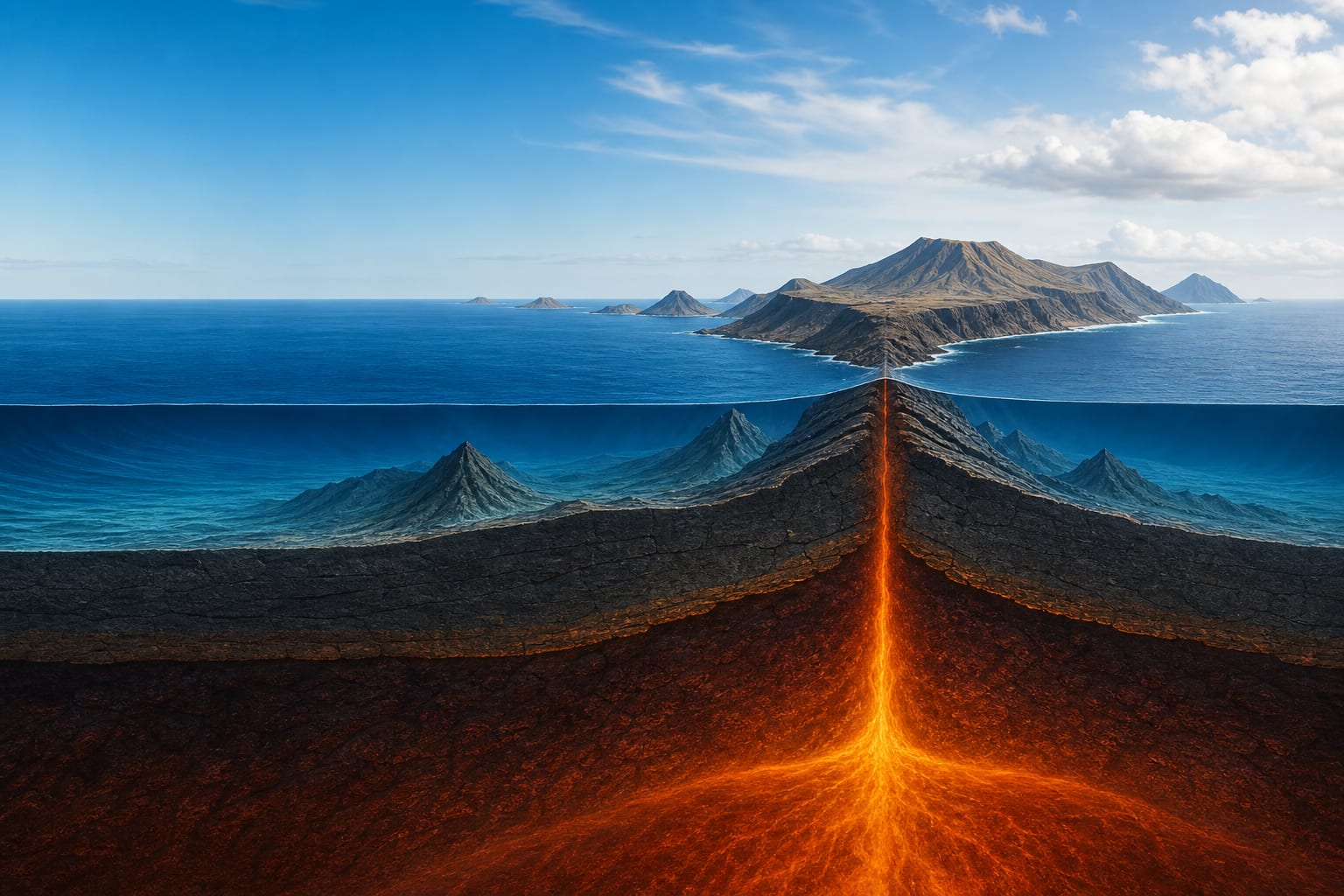
The Canary Islands are not a simple row of isolated volcanoes, but the emerged part of huge volcanic edifices built from the ocean floor. Beneath each island lie kilometres of volcanic material, intrusions, marine sediments and deep structures that explain why the visible relief is only the latest layer of a much longer history.

That history combines construction and loss: magma raises islands, gravity breaks flanks, the sea cuts coasts, rainfall opens ravines and new eruptions cover older landscapes again. The archipelago is best understood as a living system on a geological timescale, where young, mature and rejuvenated islands coexist in the same territory.

Illustration of a Canary volcanic island built from the ocean floor
A volcanic island is the visible summit of an edifice that begins several kilometres below the sea.

From the ocean floor to the first islands

The story begins under the sea, on old oceanic lithosphere close to the African margin. Internal forces fractured the crust and allowed magma to rise. Long before a recognisable island existed, volcanic activity was submarine: pillow lavas, dikes, ocean-floor sediments and deep rocks formed the base of the edifice.

This early assemblage crops out today in Fuerteventura, La Palma and La Gomera. Its presence is an essential clue: it shows that part of what we now see in ravines, calderas or ancient massifs was originally beneath the ocean and was later exposed by uplift, volcanic intrusions and erosion.

When volcanic materials rose above sea level, the proto-islands entered the open air. From then on, growth became more visible: fluid lava flows stacked one over another, cones buried by later eruptions and red almagre layers marking pauses long enough for soils to form between eruptive episodes.

Models for explaining the origin

The Canaries share features with hot-spot volcanic chains, but they do not fit neatly into the classic model of a fast-moving plate crossing a fixed source. The slow movement of the African plate, the age of the lithosphere and the proximity to the continent mean that several explanations complement one another.

A persistent mantle anomaly

The strongest explanation links the Canaries to a deep source of heat and magma. Unlike more linear oceanic chains, the African plate moves slowly, so volcanism can overlap between islands and remain active for very long periods.

Old, rigid lithosphere

The islands stand on old, thick oceanic crust close to the African margin. That rigidity helps explain why the Canaries keep emerged relief for longer and do not subside as rapidly as some other volcanic archipelagos.

Fractures that guide ascent

Fractures, uplifted blocks and regional stresses do not explain the whole archipelago on their own, but they help show where magma rises and why many eruptions are organised along ridges or rifts.

Relative age of the islands

The formation sequence helps read the archipelago from east to west, from older islands towards younger ones. The figures refer to approximate ages of emerged materials, not to the absolute beginning of each submarine edifice, so they are useful for comparison but should not be read as a single birth date.

1. Lanzarote19 million years
2. Fuerteventura16.6 million years
3. Gran Canaria16.1 million years
4. Tenerife15.7 million years
5. La Gomera12 million years
6. La Palma1.6 million years
7. El Hierro0.75 million years

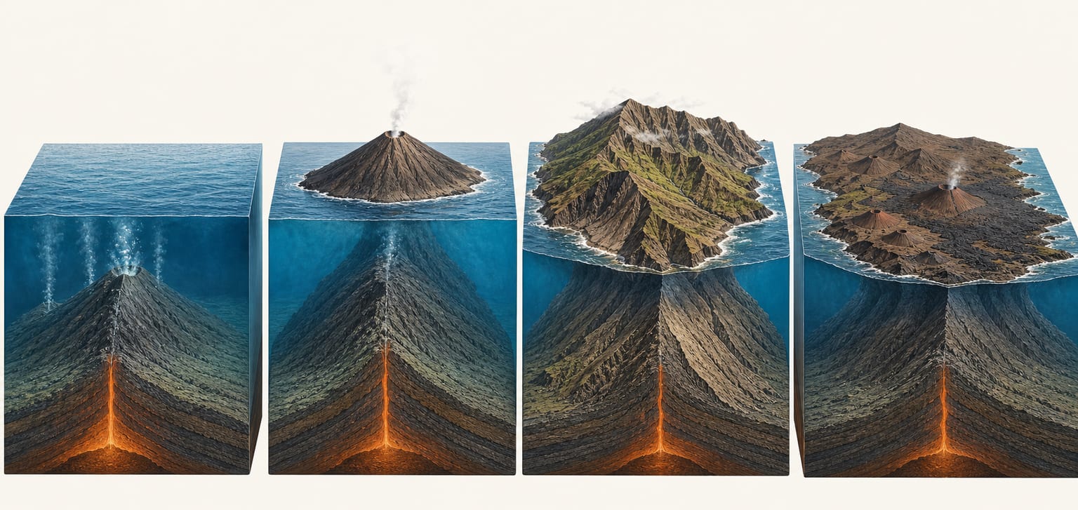
Stages of island evolution

Illustration of the evolution of a volcanic island from the submarine stage to rejuvenation
The geological life of an island alternates construction, dormancy, erosion and volcanic reactivation.

The islands are not all at the same point in their geological lives. Some are still growing vigorously, others are in long periods of dormancy, and others show recent volcanism on deeply eroded relief. This coexistence of ages is one reason La Palma and Fuerteventura can seem to belong to very different geological worlds.

Shield-building stage

La Palma and El Hierro, with Tenerife in a late stage

High edifices, stacked lava flows, dike swarms and active ridges dominate. The island gains mass faster than erosion can remove it.

Dormancy and erosive incision

La Gomera as a clear reference

Volcanism weakens or disappears for long intervals. Rainfall, the sea and gravity open ravines, dismantle old ridges and expose deeper materials.

Post-erosional rejuvenation

Fuerteventura, Gran Canaria and Lanzarote

New eruptive pulses appear on already lowered relief: isolated cones, lava fields, malpaís landscapes and platforms that can gain ground from the ocean.

Six keys for reading the landscape

1. The crust fractures

Upward magma pressure and regional stresses create weak zones in the oceanic lithosphere. These fractures are not simple cracks: over time they become preferred corridors for new dikes and eruptions.

2. A submarine foundation forms

Before the visible island exists, deep rocks, ocean sediments, submarine lavas and a network of dikes accumulate. This core, known as the Basal Complex, crops out today in Fuerteventura, La Palma and La Gomera.

3. The island emerges into the air

Once volcanic construction rises above sea level, erosion begins acting alongside eruptions. From then on, each island grows in layers: lava flows, pyroclasts, buried cones and reddish soils between episodes.

4. Ridges organise growth

On young islands, many eruptive vents concentrate along rifts or ridges. Their geometry influences the shape of the island, the direction of lava flows and the areas where volcanic risk can be higher.

5. The edifice becomes unstable

The weight of thousands of metres of lava, repeated dike injection and gravity can produce faults, tilting and large flank landslides. Valleys such as La Orotava, Güímar, El Golfo or Aridane can be read within that dynamic.

6. Erosion rewrites the island

The sea cuts cliffs, runoff carves ravines and wind shapes exposed surfaces. But the story does not only move toward wear: recent lava flows can cover valleys, fill depressions and create new coastal platforms.

Historical volcanism

The most recent phase is the one documented by written accounts, oral tradition or instrumental monitoring. Not all islands have recorded activity in recent centuries, but historical volcanism shows that the archipelago remains active, especially in the western sector and along ridges where fracturing is concentrated.

  • Timanfaya transformed Lanzarote between 1730 and 1736, with dozens of craters and lava flows that covered a very large part of the island.
  • Tenerife preserves several historical episodes, from eruptions transmitted by oral tradition to Garachico (1706), Narices del Teide (1798) and Chinyero (1909).
  • La Palma has a long series of historical eruptions, from Tahuya (1595) and Teneguía (1971) to the 2021 eruption at Cumbre Vieja.
  • La Gomera, Fuerteventura and Gran Canaria have no documented eruptions in the last 500 years, although they preserve lava fields and cones from earlier activity.

The landscape is also destroyed, subsides and gains land from the sea

Volcanic construction is not the end of the story. An island grows as a stack of materials with unequal strength: compact lavas, porous pyroclasts, dikes, altered layers and unstable deposits. Its own weight causes subsidence, fractures and faults that can be seen at small scale in the field or at island scale as large steps and tilting.

On young islands, rifts and repeated dike injection also favour large lateral landslides. They are not secondary accidents: they are part of the normal evolution of large oceanic volcanoes. Valleys such as La Orotava and Güímar in Tenerife, El Golfo and El Julán in El Hierro, or Aridane and Taburiente in La Palma preserve traces of those collapses and the erosion that followed.

At the same time, external agents keep working: the sea cuts cliffs and isolates sea stacks, rain creates ravines, wind shapes dunes and exposed surfaces, and humidity alters rocks into cavities. In the opposite direction, lava flows reaching the ocean can create new platforms. The archipelago’s relative stability, without rapid subsidence comparable to Hawaii, allows old islands to keep large emerged reliefs while erosion coexists with new construction episodes.

References

  • Valderrábano Fernández-Trujillo, Carlos; Hernández Luna, M. Isabel — Geología de las Islas Canarias. Construcción y evolución del paisaje. Publicaciones de la Consejería de Educación del Gobierno de Canarias.
  • Carracedo, Juan Carlos; Day, Simon J.; Guillou, Hervé; Rodríguez Badiola, Eduardo; Cañas, José Antonio; Pérez Torrado, Francisco J. — Origen y evolución del volcanismo de las Islas Canarias. Ciencia y Cultura en Canarias, pp. 67-91.